

You must log in or # to comment.
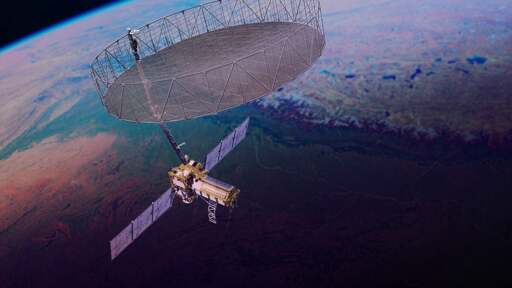
“NISAR, short for NASA-ISRO Synthetic Aperture Radar, is designed to produce a three-dimensional view of Earth in unprecedented detail.”
Also — the antenna is about the length of a school bus per the article.
A first-of-its-kind satellite recently launched into orbit to monitor Earth’s changing surfaces, detecting movement of the planet’s crust down to fractions of an inch.
The reflector is as wide as the length of a school bus, enabling NISAR to image Earth’s surface down to pixels about 30 feet (10 meters) across.
How do these statements correlate? Does it mean that they can measure height variation inches level?
also, if they scan nearly the whole planet every 12 days with that precision, where and how do they store the data?